Edward Burtynsky. Pengah Wall #1, Komodo National Park, Indonesia, 2017
Presentation
Curatorial text (selection)
The term Anthropocene is derived from the Greek anthropos, "man." It was introduced in the year 2000 by the Dutch atmosphere chemist and scholar Paul J. Crutzen and Eugene Stoermer. Since then, with much credit to the efforts of the Anthropocene Working Group (AWG), there has been discussion about the possibility that the beginnings of this new geological epoch could be traced back to the advent of industrialization, around 1780 approximately, or to 1950, when the so-called "bomb spike" signals-the dispersion of radionuclides after the dropping of the first atomic bomb in 1945-were recorded for the first time. Some have objected to the term, positing that the exploitation of natural resources and polluting of the water and air should not be attributed to human beings as a whole, but only to us Westerners, members of the OECD. From this point of view, the all-encompassing nature of the Anthropocene concept would run the risk of de-politicizing responsibilities. Some cultural theorists have preferred to coin other terms, "Capitalocene," for example, because the transformation of the earth, air and water is ultimately a consequence of capitalism. Whatever the case, the word Anthropocene suggests that humanity is no longer part of nature, but dominating and rewriting it.
With the sheer power of his images and focus on symmetries, circles, grids, and dynamically traced geometric lines, Edward Burtynsky provides a counterpoint to the proliferation of this dense and intricate network of interference with nature. A crescendo of colours and forms in large-format stills is unleashed, and with the videos by Jennifer Baichwal and Nicholas de Pencier -and their meticulous choice of angles, shots and pacing- we are presented with an array of irresistibly powerful images, comparable to Beethoven's Fifth Symphony. The artists evoke visual universes that blend the internal and external, the here and the elsewhere, the near and the far, triggering a jumble of thoughts and emotions. The effect is amplified by the strong contrast between the wonders and the indescribable beauty of nature and the technique of augmented reality which can reconstruct a past world, like the pyre of elephant tusks that represented a vibrant message of protest against the ivory trade.
Urs Stahel
Exhibition curator
 Edward Burtynsky. Basque Coast #1, UNESCO Geopark, Zumaia, Spain, 2015
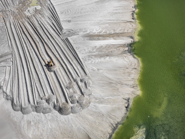
 Imperial Valley #4, California, USA, 2009
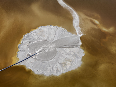
 Satellite Capture, Near Buraydah, Saudi Arabia, 2018
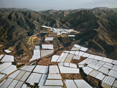 Greenhouses #2, Near Balanegra, Southern Spain, 2010
 Solar Project #1 Cerro Dominador, Atacama Desert, Chile, 2017
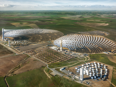 PS10 solar power plant, Seville, Spain, 2013
Gallery 1
Edward Burtynsky. Basque Coast #1, UNESCO Geopark, Zumaia, Spain, 2015 Edward Burtynsky. Greenhouses #2, Near Balanegra, Southern Spain, 2010 Edward Burtynsky. Solar Project #1 Cerro Dominador, Atacama Desert, Chile, 2017
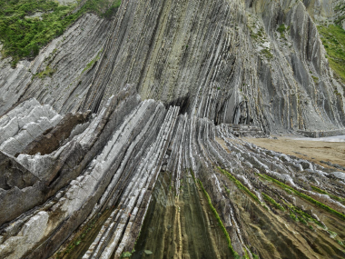
The beach that is part of the UNESCO Global Geopark, located on the Spanish Basque coast, is a unique landscape where geological time becomes visible through spectacular layers of sedimentary rock. Its length, only eight kilometers, accounts for a time scale of approximately 60 million years, and a record of two geological eras is present in the rock. A unique microcosm of Earth's history. This work inaugurates the Anthropocene project and is one of the markers showing the evolution of the planet.
Imperial Valley #4, California, USA, 2009
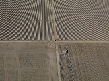
Agriculture is a relatively recent activity with about 12,000 years of history. "Working the land," argues Burtynsky, "is the greatest thing we have ever done to transform the surface of the planet." California's Imperial Valley agricultural region is one of the most active in growing winter salad vegetables. Currently, more than 80% of water consumption in the U.S. goes to agriculture. Attempts have been made to reduce its use in this area, with several programs giving farmers support to let their land rest for several seasons. The historic tension between urban and rural livelihoods continues, as farmers – who use 85% of Colorado's water supply – resist changing their practices.
Satellite capture, near Buraydah, Saudi Arabia, 2018
The image, which could be considered abstract, depicts a procedure of intensive irrigation of cultivated land in the vicinity of Saudi Arabia. For the first time in his career, Burtynsky used multiple high-resolution satellite images to document a vast area — about 163 square kilometers — of this industrial agricultural desert. The water used in this area is known as "fossil water" since it is groundwater that was stagnant in aquifers during the last Ice Age, more than 10,000 years ago.
The image shows crop irrigation in circles to increase crop yields. In the early 1990s, government programs to boost production made this Asian country one of the world's leading exporters, increasing pressure on water consumption. As a result, oases that existed since biblical times have dried up as agriculture depleted groundwater sources. As of 2017, organic farming practices were intensified in order to reduce the depletion of natural resources and avoid putting the survival of the planet at risk. An efficient and sustainable alternative is drip irrigation.
Since the nineteenth century, farmers in many arid regions of Spain have practiced dry land agriculture, making it productive. At present, the province of Almeria has ceased to be one of the poorest regions of the country to become one of the richest. In order to provide fresh vegetables for European cities, almost 400 square kilometers are now completely covered with plastic greenhouses, thus giving the region the name "sea of plastic". The workforce is almost entirely composed of migrant workers – mostly from Africa – who, according to a UN report, are under a regime of "modern slavery".
Rainfed agriculture #4, Monegrillo, Spain, 2010
The increased number of fish farms and the development of fish farming generated an industrial development in fish hatcheries resulting from new technologies introduced in the 90s and onwards. The Bay of Cadiz is considered a natural park and heritage area yet many of the traditional ponds have been abandoned. Polyculture may survive alongside industrial fish farms; however, without maintenance, this landscape and its biodiversity could disappear as a result of erosion and desiccation due to sedimentation.
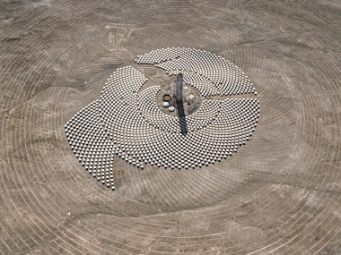
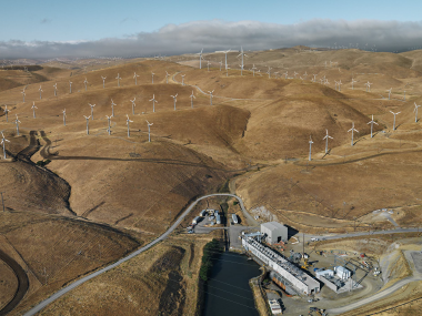
The Atacama Desert is one of the best locations in the world for solar energy harvesting. Perched at an altitude of 1,500 meters above sea level, the desert is exposed to a full, bright, and hot sunshine, which is only obstructed by clouds two or three days a year. When completed, the solar park seen here will collect heat in mirrors that follow the sun in the same way that flowers do. Most of the energy generated in facilities such as this is sold to industry. With the aim of controlling climate change and reducing environmental damage, various investment programs are being promoted that encourage the development of new renewable energy technologies and facilities.
PS10 solar power plant, Seville, Spain, 2013
The city of Seville, in southwestern Spain, receives a great deal of sunlight; give or take an average of 320 days a year, at a rate of nine hours or more each day. At the peak of any given summer the temperature can rise to 50 ºC, and the sun can shine for more than 15 hours a day, becoming an ideal place for the "collection" of solar energy. Inaugurated in 2007, PS10 was the first commercial thermoelectric solar power plant; the group to which it belongs aims to extend this type ofenergy, reduce CO2 emissions, and present a reliable, sustainable and ecological alternative to traditional models.
South Bay pumping plant #1, near Livermore, California, USA, 2009
 Edward Burtynsky. Aserraderos #5, Lagos, Nigeria, 2016
 Cathedral Grove #1, Isla de Vancouver, Columbia Brit�nica, Canad�
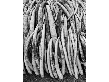
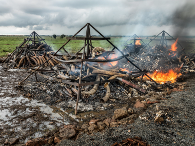 Ivory Tusk Burning #1, May 1, Nairobi, Kenya, 2016
 Jennifer Baichwal - Nicholas de Pencier. Elephant Tusk Burn, Nairobi National Park, Kenya, 2018
 Edward Burtynsky. Pengah Wall #1, Komodo National Park, Indonesia, 2017
 Jennifer Baichwal - Nicholas de Pencier. Coral Bleaching, Great Barrier Reef, Australia, 2018
Gallery 4
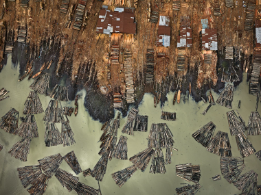
Edward Burtynsky. Sawmills #5, Lagos, Nigeria, 2016
Through an aerial shot of the city of Lagos, Burtynsky shows the alterations that the timber industry causes in the landscape; numerous floating structures used to transport wood are the central figures in this scene. The activity, associated with such a versatile -and therefore, in demand- raw material, has encouraged deforestation in certain areas, complicating the conservation of local biodiversity. The exponential increase in international consumption requires greater exploitation of this natural resource, which apparently still fails to meet the needs of the market. In turn, the economy of these cities and their inhabitants depends almost exclusively on an activity that leads to a drastic reduction of tropical rainforests and freshwater forests.
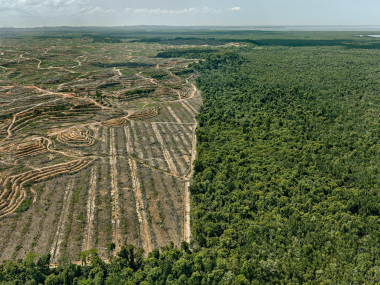
Clear cutting #1, palm oil plantation, Borneo, Malaysia, 2016
In parts of Malaysia, forest fires generated by the “slash-and-burn” process have devastated areas of rainforest. This procedure is becoming increasingly common and is used to encourage the planting of palm oil. The process of agricultural renewal involves burning the land, a practice designed to reuse land at low cost. Palm oil, one of the world's major raw materials, is found in everyday household products such as toothpaste and processed foods. Its production is reaching very high levels, accelerating deforestation processes and, in turn, driving the displacement of wildlife, indigenous peoples and one of the few habitats where the orangutan lives. In order to reverse the situation, significant changes are being encouraged at the grassroots level of organizations to begin working towards sustainable production practices. However, without the full cooperation of the large multinationals that buy refined palm oil, these systems cannot completely stop large-scale destruction.
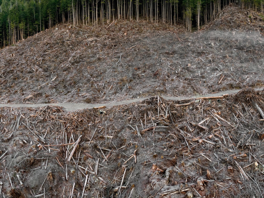
Clear cutting #5, Vancouver Island, British Columbia, Canada, 2017
A view from the height of the stumps of what were once trees clearly reveals the alteration of the terrain after tree felling; a shot that captures the scene after the destruction of vast tracts of wilderness. The depletion of these forests led to a new problem, the release of carbon from these sites greatly exceeds the absorption capacity; it takes about 13 years for young trees to achieve a net carbon sequestration effect.
Cathedral Grove #1, Vancouver Island, British Columbia, Canada, 201
Jennifer Baichwal and Nicholas de Pencier
Extension #1, Cathedral Grove, Portraits of Ancient Trees, Port Renfrew, Canada, 2018
Extension #2, Cathedral Grove, Tree felling, Port Renfrew, Canada, 2018
Extension #3, Cathedral Grove, Clear-cutting, Port Renfrew, Canada, 2018
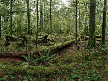
Cathedral Grove is a rare virgin spruce forest located on Vancouver Island. It is a 157-hectare protected area or 'stand' of century-old trees, some of which are over 800 years old and 75 metres tall. Although irreplaceable, forests are being cut down at a rapid pace. With the Anthropocene Project, the artists also hope to draw attention to what Burtynsky describes as "wonderful ecosystems that are in danger, a biodiversity that we risk losing."
Edward Burtynsky. Ivory Tusk Burning #1, May 1, Nairobi, Kenya, 2016
Jennifer Baichwal - Nicholas de Pencier. Elephant Tusk Burn, Nairobi National Park, Kenya, 2018. Video, 7'58"
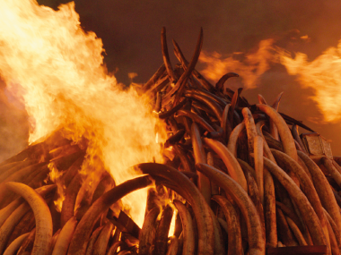
In 2016, twelve piles of ivory were set on fire and incinerated in Nairobi National Park. Authorities had amassed 105 tonnes of elephant tusks and half a tonne of rhino horns. "Tomorrow we will burn more than a hundred tonnes of ivory. It will be a pleasure to do my part to destroy any possibility of poachers and their accomplices profiting from the killing of elephants in Kenya," President Uhuru Kenyatta wrote in The Star newspaper. "If I don't take preventive measures, our children will be the first Africans in ten thousand years to grow up without these beautiful animals." According to estimates, unscrupulous hunters, whose sole target is precious tusks, slaughter between 20,000 and 35,000 elephants a year in Africa. In most parts of the world, ivory trade has been banned since 1989. However, some African countries have managed to obtain exemptions to the rule. The Kenyan government is currently pressuring the international community to sign a global ban on ivory trade.
Edward Burtynsky. Pengah Wall #1, Komodo National Park, Indonesia, 2017
Jennifer Baichwal and Nicholas de Pencier
Pengah Mural Extension #1 Coral Portraits, Komodo National Park, Indonesia, and Great Barrier Reef, Australia, 2018
Pengah Mural Extension #2 Reef Life, Komodo National Park, Indonesia, 2018
Pengah Mural Extension #3 Bleached Coral, Great Barrier Reef, Australia, 2018
Coral Bleaching, Great Barrier Reef, Australia, 2018
Through a mural installation and a series of accompanying videos that are triggered in it, the artists immerse us in the issue of coral bleaching and the resulting tension between its preservation and stress-induced loss of coloration. The large-scale reef that we observe, located in Komodo, Indonesia, is one of the most important conservation specimens due to the diversity of species that inhabit it. The complexity of photographing these ecosystems lies in the dynamic forces of flows, tides and currents which in turn, result in a vibrant document.. The decline of these habitats is largely due to the action of corrosive forces caused by climate change and consequently, rising seawater temperatures. One of the largest bleaching events took place in one of the world's largest reef systems, located in northwest Australia.
Courtesy of the artist and Nicholas Metivier Gallery, Toronto
Complementary texts
Edward Burtynsky. Basque Coast #1, UNESCO Geopark, Zumaia, Spain, 2015
Itzurun Beach, part of Spain’s Basque Coast UNESCO Global Geopark, is a unique landscape where geologic time is made visible through dramatic layers of sedimentary rock called flysch. These turbidite fans, composed of fine, alternating deposits of shale and sandstone, are only possible along such coastal shorelines as the one pictured here, where sediment builds up on deep-sea floors adjacent to evolving mountain chains. When the seafloor is pushed up into land through tectonic forces, this jagged layering occurs (leaning from west to east; oldest to newest), a result of underwater avalanches that slide down the slopes of the seabed. As the materials rest on the ocean floor, different sedimentation speeds cause a gradation effect. Bigger particles, such as sand and other course material, settle first to form the ground layer which is then overlaid by increasingly finer particles, resulting in the unique strata along this coast. The length of this eight-kilometer beach represents a timescale of approximately 60 million years, estimated to stretch from 100 million years ago to 40 million years ago. Of particular relevance to the stratigraphic consideration of the Anthropocene, Itzurun Beach contains a complete record of the boundaries between two geologic ages, the Cretaceous-Paleogene (K-Pg boundary) and Paleocene-Eocene, and indicators of their associated mass extinctions. The sequence indicates changes in the marine organisms of the time, including traces of deep-sea benthic foraminifera which experienced a major extinction during this period of warming.
This ridged shoreline is also home to two noted Global Boundary Stratotype Sections and Points (GSSPs) within the Paleocene epoch, indicating the bases of the Selandian and Thanetian stages. Commonly referred to as Golden Spikes, these stratotypes are the formal demarcation of a geological time unit. At time of writing, the Golden Spike of the Anthropocene has yet to be determined. Altogether, this stretch of flysch-covered coast in Basque country presents a unique microcosm of Earth’s history and potential trajectory; world-changing events are now visible only as thin layers of rock. Considering that agriculture was developed only some twelve thousand years ago, the flysch at Zumaia serve as sobering reminders of the impact humanity has imposed on the planet in such a short time.
Imperial Valley #4, California, USA, 2009
The Imperial Valley is a low-lying desert located at the southeast end of the Salton Sea. Since the 1940s, when significant water resources were made available through the All-American Canal, the Imperial Valley has become an important agricultural region, growing $2.3 billion worth of agricultural products in 2013,1 most famously, winter salad vegetables. As the valley’s only water source, the canal controls about 20 percent of the Colorado River’s total annual output.2 Agricultural runoff drains directly into the nearby sea, carrying salts from the earth as well as nitrates and phosphorus, thus encouraging the growth of algae and bacteria, which further rob the sea of oxygen. Today, more than 80 percent of consumptive water use in the United States is for agriculture.On average, Imperial County agriculture uses 5.6 acre-feet of water per acre per year,putting significant pressure on the Colorado River water supply. In recent years attempts have been made to reduce water consumption. Several programs pay farmers annual per-acre fees to leave their land fallow. Many hope that this system will motivate farmers to conserve water even further. However, while fertilizer runoff has encouraged bacteria and algae growth, and significantly increased the salinity of the Salton Sea, reductions in Imperial Valley irrigation may well have their own negative impacts on the rapidly evaporating lake. The historical tension between urban and rural livelihoods continues as farmers, who use 85 percent of Colorado’s water supply, struggle to change their practices.
Satellite Capture, Near Buraydah, Saudi Arabia, 2018
Agricultural areas in the Saudi Peninsula are irrigated with what is known as “fossil water”—water that was trapped in underground aquifers during the last Ice Age. As this water source is a non-renewable resource, it is estimated by NASA that these aquifers will run dry within fifty years. The area that’s pictured in this satellite image is about 163 square kilometers. It is estimated that a single pivot can cover an area from 0.4 square kilometers to 0.9 square kilometers. The pumps require around 91 liters of diesel fuel per hour—another non-renewable resource made accessible because of significant fuel subsidies. Pivot irrigation, developed in the United States, was first used in Saudi Arabia in the late 1970s for water-intensive wheat crops. Reputed to be more than twice as efficient as flood irrigation, pivot irrigation—designed to irrigate crops in circles—allowed harvest yields to increase and irrigated areas to rapidly expand.
By the early 1990s, government programs to intensify production resulted in Saudi Arabia becoming a top global exporter, putting greater stress on water consumption. By the time this image was captured, production had switched to higher-value animal feed such as alfalfa and corn. Yet decreasing water levels had reduced the total farmed area by more than half since the 1990s. At the same time, spring-fed oases, existing since biblical times, dried out as underground water sources were consumed by agriculture. Most operations today use more water-efficient drip irrigation. Israeli technology, for example, delivers the exact amount of water that is needed to the roots of each plant—with no evaporation or runoff. However, these systems are very expensive, and adoption can be slow without serious incentives. As of 2017, 160 square kilometers of land have been converted to more sustainable organic farming practices, representing only 2 percent of the kingdom’s total agricultural area. Such changes must occur rapidly if the imminent collapse of Saudi agriculture is to be avoided.
For the first time in his career, Burtynsky used high-resolution satellite images to create a composite photograph, stitching together 24 pictures from a 163-square-kilometer sweep of industrial agricultural desert. Farming here requires an intensive watering system known as pivot irrigation. Designed to water crops in circles, pivot irrigation puts stress on the water supply and dries out underground water sources.
Burtynsky’s view from above, with its set of geometric patterns, emphasizes this system’s scope. Water-efficient drip irrigation is a sustainable alternative. But it is expensive, and without serious incentives, industries will be slow to adopt this practice. As of 2017, drip irrigation was used to water fewer than 6,500 hectares of farmland around the world.
Courtesy of the artist and Nicholas Metivier Gallery, Toronto
 Edward Burtynsky. Greenhouses #2, Near Balanegra, Southern Spain, 2010
 Dryland Farming #40, Monegrillo, Spain, 2010
Agriculture
Greenhouses #2, Near Balanegra, Southern Spain, 2010
Since the nineteenth century, farmers in many arid regions of Spain have practised dryland agriculture. Using terraforming techniques, combined with crops resistant to dry conditions, these farmers have been able to make barren land productive. Yet the introduction of anthropogenic materials in the period following the Spanish Civil War has caused another type of earth-shaping for agriculture in the region. The province of Almería in southern Spain has come to be known as the “Mar de plástico” (“Sea of Plastic”).1 The province’s industrialization of vegetable production has transformed the community, once one of the poorest regions in the country, into one of the richest in Spain. In order to provide fresh vegetables for European cities, almost four hundred square kilometers around the municipality of El Ejido are today completely covered with plastic greenhouses. Additionally, the workforce is almost entirely made up of migrant workers, mostly from Africa, working in conditions that a 2011 report in the Guardian considered to embody the UN’s definition of “modern-day slavery.” Their inhumane living conditions have been compared to those of a refugee camp. Further, the local Sorbas-Tabernas fossil water aquifer, an ancient and non-renewable resource, is now in danger of collapse. The situation was fictionalized in the 2015 Spanish television crime drama Mar de plástico, which received condemnation from industry representatives. Yet problems continue to be documented by journalists and human rights groups. As global demand for cheap, healthy diet staples increases, it remains vital that the human cost of these products is not obscured from their consumption.
__
The coastal marshes of Spain’s Bay of Cádiz are prime examples of human- engineered biodiversity. Initially developed as salt collection ponds, polyculture fisheries were created as a means of expanding food production. A pond and marsh system, fed by two rivers as well as the tide, create this dramatic landscape. As with solar salterns, a series of ponds are built into naturally occurring salt marshes and connected by channels, encouraging a gradient of water depth and salinity. The yearly farming cycle begins in winter, when the floodgates of the reservoirs are opened to empty the pools and harvest the fish produced during the previous season. The gates then remain open for several months throughout winter and spring, before being shut once again, trapping fry (newly hatched fish) along with the organisms that will feed them. The resulting fully grown fish, as well as other species such as molluscs and crustaceans, are then collected in the autumn and early winter. This traditional system has always encouraged experimentation and adaptability. By the mid-twentieth century, the salt industry had seen a serious decline, and fish farming was increased to compensate. By the 1990s, advances in technology allowed for production to be carried out on an industrial scale. Today, traditional fish farms, while more sustainable, are not as profitable as the rapidly expanding monoculture operations. The Bay of Cádiz is considered a natural park and heritage zone, yet many of the traditional ponds have been left abandoned. It may be possible for polyculture to survive alongside industrial fish farms, but without maintenance, this landscape and the biodiversity it fosters may disappear through erosion and drying out by sedimentation.
Courtesy of the artist and Nicholas Metivier Gallery, Toronto
 Edward Burtynsky. Cerro Dominador Solar Project #1, Atacama Desert, Chile, 2017
 South Bay Pumping Plant #1, Near Livermore, California, USA, 2009
 PS10 Solar Power Plant, Seville, Spain, 2013
Cerro Dominador Solar Project #1, Atacama Desert, Chile, 2017
The Atacama Desert is one of the world’s most optimal places for solar energy. Perched at an altitude of 1,500 meters above sea level, the desert here is subject to a sun that burns bright and hot, hampered by only two or three cloudy days per year. When completed, the solar farm seen here, Atacama-1, will use a 2,000- tonne solar receiver to collect the heat from 10,600 heliostatic mirrors that follow the sun like flowers. Heat is retained in a 50,000-tonne pool of molten salt that drives turbines through the night, making this system viable for twenty-four-hour power generation. The salt is locally mined, as it is in the nearby lithium flats. Most of the energy that is generated in facilities like this is sold to industry, and a significant portion powers the Chuquicamata copper mine The very first solar-thermal towers ever built were PS10 and PS20 in Spain, which opened in 2007 and 2009 respectively. Functionally, they are very similar to the Atacama-1 tower, though they lack the liquid salt to store heat. Capital costs for all types of solar installations fell a dramatic 73 percent between 2010 and 2017.5 In 2016, solar represented about 47 percent of newly installed renewable power capacity, with wind and hydropower accounting for 34 percent and 15.5 percent respectively.6 Shifting priorities in energy investment, as well as international political efforts to control climate change, suggest that the geopolitical incentives to move away from fossil fuels may become even stronger.
South Bay Pumping Plant #1, Near Livermore, California, USA, 2009
In 2015, global power consumption totalled 575 quadrillion British thermal units (BTUs), or over 168,515 terawatts.1 In 2013, just over 30 percent of all global greenhouse gas emissions came from electricity and heat production, excluding industry.2 By the end of 2017, the global wind power capacity was estimated at 539,291 megawatts (or 539 gigawatts), representing 5 percent of global electricity demand. The cost of wind power is falling rapidly, similar to what is happening with solar power. These wind farms represent an early advance of an industry that, in combination with solar, will see three-quarters of all new power energy investment by the mid-twenty-first century.
PS10 Solar Power Plant, Seville, Spain, 2013
Two towers rise from the fields 20 miles west of Seville. Tthey serve a much more practical purpose: They are the “power towers” of Solucar, the largest solar energy complex in Europe. The towers, named PS10 and PS20, began operating in 2007 and 2009. Each is surrounded by a field of angled mirrors known as heliostats, which reflect solar radiation onto a receiver located at the top of each tower. This reflected sunlight illuminates dust and water vapor in the air, resulting in the brilliant glowing rays.
The heliostats—624 for the PS10 and 1,255 for the PS20—move during the day in order to reflect the most sunlight possible. When the rays of light reach the receiver, their heat produces steam, which is used to power a turbine. The turbine drives a generator, thereby producing electricity.
 Edward Burtynsky. Phosphor Tailings #6, Near Lakeland, Florida, USA, 2012
 Phosphor Tailings Pond #4, Near Lakeland, Florida, USA, 2012
 Phosphor Tailings #5, Near Lakeland, Florida, USA, 2012
Extractivism and terraforming
Phosphate ore is one of the world’s most critical mineral resources. Like fossil fuels, it is non-renewable. Phosphate rock (or phosphorite) deposits can be either sedimentary or igneous. The deposits mined in Florida are sedimentary, formed through the deposition of phosphate-rich materials in ancient marine environments. To access the ore, phosphate surface-mining operations must clear natural vegetation and topsoil.2 These regions are typically unable to revert back to their natural state following this polluting process, which involves the excavation and deposition of overburden and related waste disposal, thus leaving a nutrient deficient landscape in its wake.3 Phosphates, essential to all life, are crucial to industrial agriculture. A key component in DNA, phosphorus is necessary for plant energy metabolism and growth.4 However, water systems large and small are threatened by its nutrient-rich agricultural runoff. While phosphate rock is insoluble in its untreated form, when treated with sulphuric acid, it produces phosphoric acid—the water-soluble substance from which most phosphate fertilizers are derived. Runoff, from both the industrial mining of phosphates and their use in agriculture operations, is a key factor in the creation of harmful algal blooms, loss of fish species, and the pollution of vital water sources. Looking back in geological time, high levels of phosphorus have been associated with oceanic anoxic events (OAEs). Such events occur at times with low levels of dissolved oxygen in the ocean, and tend to coincide with both “greenhouse” climates and mass extinctions, like the Permian–Triassic extinction event (nicknamed “The Great Dying”). Shortly before the advent of wide-scale use of fertilizers, Sir George Knibbs’s 1928 book, The Shadow of the World’s Future, suggested that beyond a population of 7.8 billion, agricultural land would have to be made significantly more productive. Soils are a kind of contained energy, with all the nutrients necessary to life contained within them. Once those nutrients are gone, soil has no capacity for growth. There is no substitute for phosphates in industrial agriculture. With an expanding world population, demand for this essential mineral will only increase, putting ever greater pressure on already stressed ecosystems.
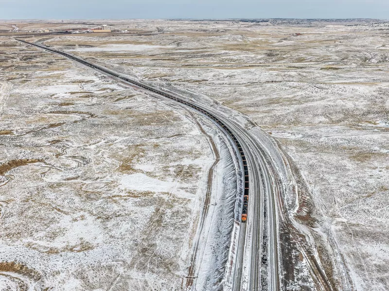 Edward Burtynsky. Fracking, Near Gillette, Wyoming, USA, 2015
Edward Burtynsky. Fracking, Near Gillette, Wyoming, USA, 2015
These images depict coal mining and natural gas fracking between Casper and Gillette, Wyoming. In 2009, the United States surpassed Russia as the world’s largest producer of natural gas, and in 2013 it surpassed Saudi Arabia to become the world’s top producer of petroleum hydrocarbons.1 As of 2016, it remained the leader in both categories. The country’s dominance is largely due to the development of multi-stage hydraulic fracturing (or fracking), a process wherein water, sand, and chemicals are pumped deep into bore wells to crack open fissures and bolster the flow of oil and gas.3 This method of oil production, which requires approximately 19 cubic metres of water per well,4 has the potential to cause significant groundwater contamination, primarily through processes that have received minimal study or regulation. By 2019, these same technologies will make the U.S. the world’s largest producer of petroleum, overtaking Saudi Arabia for the first time.5 Since the Industrial Revolution, over 390 billion tonnes of anthropogenic carbon emissions have been released into the air through cement production and the burning of fossil fuels.6 For much of the earth’s history, CO2 levels ranged between 200 parts per million (ppm) and 280 ppm. In 2013, CO2 levels reached 400 ppm for the first time on record.7 At our current rate, it is estimated that the earth’s climate will warm from 3.2°C to 5.4°C above pre-industrial levels by 2100.8 The discovery and exploitation of new methods of oil extraction ensure that until a more efficient form of energy is found, global sustainability will take a back seat to the status quo.
 Edward Burtynsky. Oil Bunkering #1, Niger Delta, Nigeria, 2016
 Oil Bunkering #4, Niger Delta, Nigeria, 2016
Oil Extractivism
Seventy percent of the Nigerian government’s revenue is tied up in the oil resources of the Niger Delta, with petroleum products making up 90 percent of all export revenues for the country.1 Since oil was discovered in the region in 1956, the resource has proven to be both a blessing and a curse.2 For decades, multinationals have abdicated responsibility for devastating oil spills onto land and into the water. Though Nigeria gained independence from British rule in October of 1960, much of the country’s oil wealth continues to be diverted outside its borders. As a result, poor communities have begun pirating crude oil from pipelines—often with the support of local elites and politicians who reap benefits—through a process known as “bunkering.”3 Tapping into pipelines, makeshift micro-refineries are set up on a temporary or semi-permanent basis to turn the crude into low-grade fuel. Some government-commissioned estimates suggest that 250,000 barrels are stolen every day, but accurate figures are unknown.4 Highly dangerous, these systems (and the broken pipelines that feed them) leak volumes of crude oil and toxic by-products into the surrounding forests and waterways. In order to build and access the pipelines, large areas of ancient forest are opened up through logging and burning. This, in turn, opens more rainforest and woodlands to (legal and illegal) logging.5 Timber is then transported downriver using booms similar to those seen in British Columbia.. For many of the logs, the final destination is Makoko, an informal community connected to Lagos . Here, sawmills process the hardwood for local use. Over time, biodiversity in the region has diminished, a result of continued deforestation and degradation.6 In 2010, Nigeria began the process of what Foreign Affairs described as “possibly the largest ever transfer of energy assets from foreign companies to local ones.”7 While the development of a localized industry certainly poses its own set of challenges, there is cautious hope that after years of corruption and violence through the collusion of government dictatorships and foreign corporations, Nigerians will start to see real benefits from the wealth of natural resources beneath theirfeet. Still, bunkering by-products continue to pollute the ruined landscapes of former forests, offering long-term reminders of the impact of global consumerpressures on this land and its people.
 Edward Burtynsky. Petrochemical Plants, Baytown, Texas, USA, 2017. (Plantas petroqu�micas, Baytown, Texas, EE. UU.)
 Freeman Island, Long Beach, California, USA, 2017. (Isla Freeman, Long Beach, California, EE. UU.)
Many refineries and pumping stations, like the one pictured here in Long Beach, California, are in the centre of major metropolitan areas; petrochemical products are integrated into every aspect of our lives and are therefore hard to replace. With no ready alternative natural resource to replace petrochemicals, finding a sustainable substitute for crude oil and all its complex carbon chains continues to prove a difficult task. Powerful corporate interests that exercise regulatory capture make shifting to alternative energies far more difficult for democratic societies to achieve.
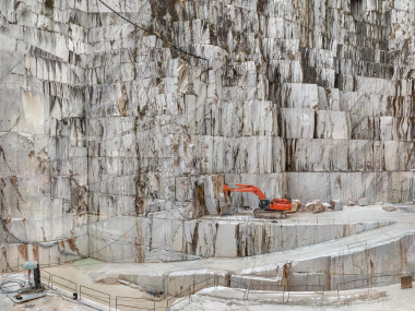 Carrara Marble Quarries, Cava di Canalgrande #2, Carrara, Italy, 2016
Carrara Marble Quarries, Cava di Canalgrande #2, Carrara, Italy, 2016
“I remember looking at a building made of stone and thinking: somewhere there has to be interesting scenery because these stones were quarried block by block.”—Edward Burtynsky
Carrara marble has been extracted from quarries located in the Italian Alps for more than 3,000 years. It was used by some of the most famous artists in Western civilization and as a building material in renowned ancient sites such as the Pantheon in Rome. Today, Italy exports this marble all over the world, from Abu Dhabi to London, and from Mumbai to Beijing. Although these great white mountains seem infinite, the resource they contain is not. Like all natural stones, marble was formed from ancient seabeds, and at some point the reserves will be depleted. While Burtynsky's mural offers a commanding sight, Baichwal's and De Pencier's extension videos allow us to delve deeper into the site and serve as a reminder of human involvement. For many, these quarries represent jobs and livelihoods.
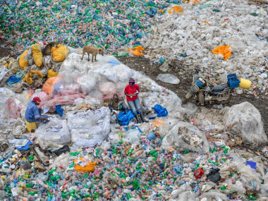
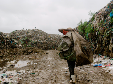 Jennifer Baichwal and Nicholas de Pencier. Basural Dandora, Nairobi, Kenia, 2018
 Edward Burtynsky. Basural Dandora #3, reciclaje de pl�sticos, Nairobi, Kenia, 201
Edward Burtynsky. Dandora Landfill #3, Plastics Recycling, Nairobi, Kenya, 2016
Jennifer Baichwal y Nicholas de Pencier. Dandora Landfill, Nairobi, Kenya, 2018
The Dandora Landfill is among the largest of its kind in the world. Referred to as Nairobi’s Municipal Dumping Site, the area receives industrial, agricultural, commercial, and medical waste, amounting to about 2,000 tonnes per day. Due to its location next to the Nairobi River, any runoff is carried into the water system. It is estimated that nearly a million people live in the vicinity of the landfill. Though steps were taken to decommission the landfill in 2012, it was never officially closed and continues to operate with no active replacement. Residents work informally, sorting scrap by hand and selling it to newly built recycling plants on site. The mounds in these images, some 4.6 meters high, are composed primarily of less valuable plastic bags. In 1950, less than 2 million tonnes of plastics were manufactured globally per year. By the early twenty-first century, this amount had reached 300 million tonnes per year. The total cumulative amount of plastics produced by 2015 was calculated to be 5 billion tons, enough to cover the entire earth in plastic wrap. Too small for typical methods of filtration, microplastics are virtually ubiquitous in our environment, and are increasingly deposited in sediment layers, making them a key technofossil for the stratigraphic consideration of the Anthropocene. In 2017, plastic bags were banned across Kenya, a move increasingly made by governments worldwide that want to reduce their nation’s plastic footprints.
The Dandora Landfill was created in the 1970s and declared full more than a decade ago. However, the municipal dumping site continues to function and provides the primary income source for many in its vicinity. An estimated six thousand people mine its fenceless grounds each day, searching for metal, rubber, glass, plastics, and electronics for resale or purchase by recycling companies. A 2007 study by the United Nations Environment Programme found fatally high levels of lead in soil samples bordering the landfill. Nearly half of the 328 local children tested suffered from respiratory problems and exhibited lead concentrations in their blood that exceeded internationally accepted levels.
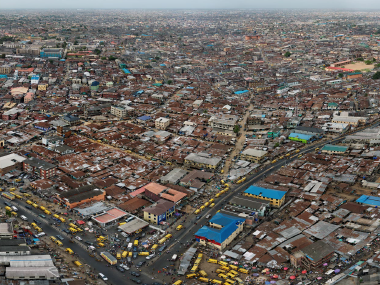 Edward Burtynsky Cruce del Mercado de Mushin, Lagos, Nigeria, 2016
Edward Burtynsky. Mushin Market Intersection, Lagos, Nigeria, 2016
The artists transport us to Lagos, Nigeria, an immense West African economic capital that has grown from 1.4 million residents in the 1970s to over 20 million today. Through the scale of this work, Burtynsky captures the city’s urban sprawl and density. The murals are the largest photographic images he has produced to date. To create this expansive composition, he digitally stitched together hundreds of individual photographs. The end result is an image of extraordinary detail that exceeds what our eye alone could see if we were lucky enough to gaze upon the same view.
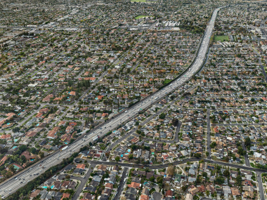 Edward Burtynsky. Autopista #8, Santa Ana Freeway, Los �ngeles, California, EE. UU, 2017
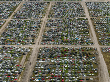 Flood Damaged Cars, Royal Purple Raceway, Baytown, Texas, USA, 2017
 Makoko #2, Lagos, Nigeria, 2016
Edward Burtynsky. Highway #8, Santa Ana Freeway, Los Angeles, California, USA, 2017
Urban sprawl is not easily described, yet most people seem to know it when they see it. Though it has become increasingly dense over time, Los Angeles represents the origin of and model for the type of urban sprawl we see today: large areas of separated land use, single family houses with yards, and a reliance on the automobile. It is the archetypal image of the American Dream, exported around the world.
The development of the California freeway system in the early to mid-twentieth century was a catalytic moment for the development of large-scale urban sprawl. In the twenty-first century, the explosion of urban development in China has outpaced the rate of change elsewhere. As with the early development of urban sprawl in the Los Angeles area, the critical infrastructure required for this type of expansion in China is the highway. Much like California’s suburbs, China’s new megacities are marked by low-density development, which presents numerous footprint issues as the global population grows.
Flood Damaged Cars, Royal Purple Raceway, Baytown, Texas, USA, 2017
In the fall of 2017, Hurricane Harvey’s rainfall triggered catastrophic flooding in Houston, causing widespread destruction. In the aftermath, between 30,000 and 40,000 storm-damaged vehicles were temporarily stored at this Texan raceway. The cars that fill our vista were eventually returned to their owners, sold for parts or demolished. If you were standing in this automobile graveyard, you would see the nearby sprawling industrial complexes of Houston’s petroleum industry.
Oil production has been a major factor in increasing carbon dioxide (CO2) in the earth’s atmosphere, affecting climate patterns. For example, just a 1°C jump in the average global temperature would cause extreme weather events, like hurricanes Harvey and Katrina, to occur at seven times their current frequency.
Makoko #2, Lagos, Nigeria, 2016
As one of the fastest-growing countries in the world, Nigeria has seen large areas of its ancient forest decimated, especially in recent years. Log booms, such as the ones pictured here, transport raw timber downriver from the Niger Delta to Makoko, the final destination for much of the collected resource. The densely populated, informal settlement is home to an expansive forest industry, with abundant sawmills and myriad markets for wood. As Makoko is situated atop the water, thus earning its nickname, “Venice of Africa,” the logs that reach Makoko’s shores can be easily accessed, processed, and sold to eager markets. The emergence of Nigeria as an increasingly industrial nation has not been without cost: by 2011, 40 percent of the Delta’s lowland rainforests had been lost due to agriculture and logging, while freshwater forests had been reduced by nearly a third. Over time, biodiversity in the region has steadily diminished. For the wood merchants of Makoko, the threat of this increasing deforestation is tangible—their primary source of income is mostly dependent on a natural resource in such high demand that its popularity will inevitably result in its disappearance.
 Edward Burtynsky. Mina de Carb�n #1, Renania del Norte, Westfalia, Alemania, 2015
 Edward Burtynsky. Mina Tyrone #3, Silver City, Nuevo M�xico, EEUU, 2012
 Edward Burtynsky. Mina Morenci #2, Clifton, Arizona, EEUU, 2012
 Edward Burtynsky. Sobrecarga #1 de la Mina de Cobre Chuqicamata, Calama, Chile, 2017
 Edward Burtynsky. Mina de Potasa Uralkali #4, Berezniki, Rusia, 2017
 Edward Burtynsky. Lithium Mines #1, Salt Flats, Atacama Desert, Chile, 2017
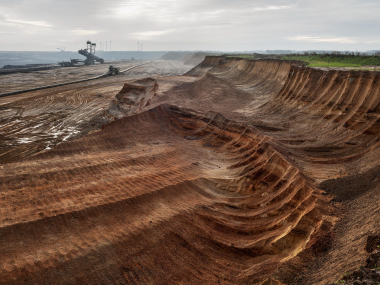
Edward Burtynsky. Coal Mine #1, North Rhine, Westphalia, Germany, 2015
The Hambach mine is the largest open-pit mine in Germany. The coal at this mine can only be reached by removing mountains of unwanted material, which is then dumped on the land to form a massive man-made hill, a task that requires unique heavy machinery. The mine at Hambach features the Bagger 291 and 293, which are among the largest land vehicles in human history, by weight. Bucket-wheel excavators such as these remove the sandy overburden covering the coal. At a rate of 240,000 cubic meters of material per day, the Bagger 293 removes approximately 220 to 250 million cubic meters of overburden every year. The entire machine stands at 220 meters in length and 94.4 meters in height. It has eighteen buckets in total, each of which can hold more than 5 cubic meters of sand or coal. The lignite, or soft brown coal, produced at the 85-square-kilometer Hambach mineaccounts for approximately 5 percent of the country’s energy. Lignite is a particularly inefficient and dirty type of fuel. As incidents of protest increase, the future of extraction in the region is unclear. Despite significant investments in renewable energy, Germany still leads the EU for carbon emissions as of 2017.7 Since Hambach’s opening in 1978, four villages have been evicted because of the mine’s expansion, and two more are currently facing relocation. Expansion has also caused the near-complete removal of the ancient Hambach Forest, despite resistance from protestors who have occupied the site for several years. Recent estimates suggest that only 10 percent of seventy square kilometers of woodland remain. The Bagger 291, pictured here, is a bucket wheel excavator used in the mine to remove overburden.
Mina Tyrone #3, Silver City, Nuevo México, EEUU, 2012
Burtynsky’s first photographs of mines were of coal tailings in a small Pennsylvania town in 1982. He has since photographed tailings and overburden in sites across the globe.
“I have come to think of my preoccupation with the Anthropocene as a conceptual extension of my first and most fundamental interests as a photographer,” explains Burtynsky. “I have always been concerned with showing how we affect the earth in a big way.”
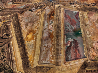
Mina Morenci #2, Clifton, Arizona, EEUU, 2012
Like most extractive practices, copper smelting is highly water-intensive, requiring between 1,500 and 3,000 liters of water for every ton of processed ore. This can be seen in the aerial photographs from Arizona, the United States’ primary copper producing region, in which large tailing ponds contain liquid reserves of the effluents left by the copper extraction process. The swirling, marble-like colors are the result of leached heavy metals. Overburden (all soil above the bedrock) and waste rock (the portion below the cut-off grade for copper) are also removed in heap leaching, the method most commonly employed in the United States. A significant amount of the water is recovered from tailings ponds and recirculated through the industrial process, but about 750 liters of fresh water is still required for every ton of ore. At some mines, systemic improvements have reduced that amount to 340 liters per ton.5 With most operations located in arid environments, every liter counts.
Coal Mining, Near Gillette, Wyoming, USA, 2015
“It’s hard not to marvel at the engineering ingenuity of the massive industrial sites we filmed, and equally hard to ignore the devastation they represent.”—Nicholas de Pencier
Wyoming produces 40 percent of America’s coal, a non-renewable fossil fuel. Coal mining is a key marker of the Anthropocene. Since the Industrial Revolution in the late 1700s, over 390 billion tonnes of carbon emissions have entered the atmosphere through the burning of fossil fuels and other industrial activity. Excessive carbon is a main contributor to climate change.
In many areas, legislators and residents are trying to reduce their dependency on coal and other fossil fuels for energy. In 2003, coal provided 25 percent of the power generated in Ontario. The province made a pledge to eliminate coal as a source of energy and successfully hit this target in 2015.
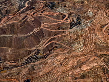
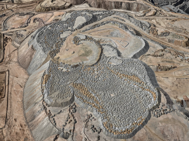
Chuqicamata Copper Mine Overburden #1, Calama, Chile, 2017
The Chuquicamata copper mine, popularly known as Chuqui, has been in continuous production for over a century. It is one of the world’s largest open-pit mines, with the capacity to process 350 kilotons of ore annually in its onsite smelters. Copper has been mined by humans in this region for millennia and Chile has been the world’s largest supplier of copper since the year 2000. Copper mining today, as in the past, is primarily done through open-pit methods. The difference now is the incredible scale. Chuquicamata is situated on 120 square kilometers of land, the mine itself being 4.5 kilometers long and 3.5 kilometers wide, with an open-pit depth of almost a kilometer. In 2012, after a century of industrial mining, construction began on an underground mine to extract Chuquicamata’s remaining reserves. Projected figures from the site suggest that Chuqui will eventually produce an estimated 140,000 tonnes of ore per day, as well as 366,000 tonnes of copper and 18,000 tonnes of fine molybdenum per year. In 2009, the United States Geological Survey estimated that every American born in 2008 will use 593.7 kilograms of copper throughout his or her lifetime. As a highly recyclable material, recovered copper takes 85 to 90 percent less energy to produce than copper that is newly mined from the earth. The value of new copper as opposed to its recycled counterpart, however, ensures that global demand will encourage mines to be dug until their resources are exhausted.
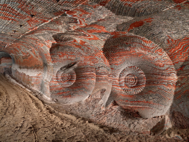
Up to four hundred meters beneath Berezniki, Russia, tunneling machines, referred to as “combines,” reveal vividly coloured layers from an ancient sea floor. While the strata of Zumaia were raised above sea level, these mineral salts remained underground. Today, they have been revealed through the mining of potash—an indispensable fertilizer.
As the combines pass through, they leave behind impressions in the soft rock that can look like fossils of the ancient sea life from which they were formed. These colorful walls contain the minerals that make up potash—a combination of halite, carnallite, and sylvite. Completely envel oped in darkness, and stretching for an estimated three thousand kilometers, these tunnels were incredibly difficult to film. They are for the most part stable, and will leave behind a record of our presence through anthroturbation (large-scale human tunneling under the earth). Five mines operate in and around the city of Berezniki, collectively composing an underground web of an estimated ten thousand kilometers of tunnels. As a result, the town of Berezniki has experienced giant sinkholes that have swallowed roads and buildings and shut down the local railway station. Many residents have moved, despite the jobs available at the mines; there have even been calls to relocate the entire town. The potash mined here is ultimately destined to fertilize large industrial farms, like those in the Imperial Valley in California.
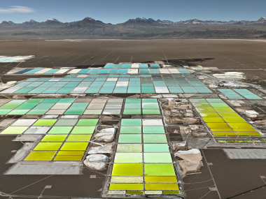
Brine Wells #1, Salt Flats, Atacama Desert, Chile, 2017
Lithium Mines #1, Salt Flats, Atacama Desert, Chile, 2017
The otherworldly landscape of the Salar de Atacama is the driest non-polar desert on the planet. This picturesque salt flat rips tires to shreds and makes foot crossings practically impossible. Located amidst this barren, surreal landscape is one of the largest known lithium reserves on the planet, containing 27 percent of the world’s lithium reserve base. Receiving almost no rain, the Salar has absorbed water from well outside its drainage basin for millions of years. This water sank into the arid flats, creating ancient reserves of mineral-rich brine deep below the surface. Declared a strategic resource by the Chilean government in the 1970s, lithium is the core component of lithium-ion batteries. To extract lithium salts, brine is pumped up from the salt basin beneath the Salar. It then evaporates by the heat of the sun in a series of artificial evaporation ponds much like the artisanal systems seen in Gujarat, India or the Bay of Cádiz in Spain. As the liquid evaporates, the ponds move through a series of colour stages until their lithium concentration is determined to be high enough to be shipped for refining. Since the emergence of electric vehicle manufacturer Tesla, concerns have been raised that there will be a deficit in the lithium supply. While this may bring about short-term price problems, lithium power has the potential to significantly reduce our carbon footprint. With major powers like the United States and China actively working to ensure the development and expansion of the lithium supply, the metal is poised to become one of the most valuable commodities of the twenty-first century.
 Edward Burtynsky. Clearcut #5, Vancouver Island, British Columbia, Canada, 2017
 Clearcut #1, Palm Oil Plantation, Borneo, Malaysia, 2016
Deforestation
Edward Burtynsky. Clearcut #5, Vancouver Island, British Columbia, Canada, 2017
“As someone who is compelled to chronicle places and events with cameras, I am drawn to those subjects which inspire me and which worry me. The themes and locations we have chosen for Anthropocene do both.” — Nicholas de Pencier
Clearcut #1, Palm Oil Plantation, Borneo, Malaysia, 2016
In Borneo, the clearcutting of rainforests to make way for palm oil plantations is more and more common. Farmers light fires as part of an agricultural renewal process: the land is set ablaze, oil palms bear fruit and the cycle repeats.
Palm oil is everywhere. It’s in our food, cosmetics, cleaning products and fuel. Although the oil is a highly valuable resource, palm plantations are contributing to record levels of deforestation and, in turn, the displacement of Indigenous people and wildlife such as the endangered orangutan.
 Edward Burtynsky. Cathedral Grove #1, Vancouver Island, British Columbia, Canada, 2017
Edward Burtynsky. Cathedral Grove #1, Vancouver Island, British Columbia, Canada, 2017
Cathedral Grove is a rare old-growth forest of Douglas fir trees on Vancouver Island. It is a 157-hectare protected area or “stand” of ancient trees, some of which are over 800 years old and more than 75 metres tall. Although irreplaceable, British Columbia’s old-growth forests are being logged at a rapid rate. With The Anthropocene Project, the artists hope to also bring attention to what Burtynsky describes as “wondrous ecosystems that are endangered, the beauty and biodiversity that we are at risk of losing.”
These images depict great rainforests under stress. The temperate rainforests of the Pacific Northwest coast are an incredible site of biodiversity. British Columbia, whose rainforests are pictured here, occupies only 10 percent of Canada’s geographical area, yet the province contains more than half of Canada’s vertebrates and vascular plants, as well as three-quarters of its bird and mammal species.1 Some of the tallest trees in the world can be found in the old-growth forests of this region. Commercial logging on Vancouver Island dates back to the 1820s, with the first sawmills being established in the 1860s.2 The introduction of the combustion engine in the 1940s saw previously unreachable forested areas turned into logging sites, their timber then easily transported by road.3 Today, 90 percent of B.C.’s logging occurs on publicly owned Crown lands.4 While less than 1 percent of the province’s forests are harvested annually,5 Vancouver Island’s primary rainforests are logged at three times the rate of tropical regions.6 As of the early twenty-first century, only 10 percent of Vancouver Island’s old-growth forests remained, and logging of these spaces continues.7 By 2017, merchantable pine from the B.C. Interior was reduced by more than half due to mountain pine beetle infestations.8 As climate change encourages further infestations, among other impacts, logging companies will increasingly focus on exports from the coasts.9 Like those at the saw mills beside Makoko in Nigeria, log booms are used to transport raw timber from the area where it was harvested to central log yards (pages 97, 104–105). In both cases, increasingly globalized economies have led to mass export of local resources. In the case of British Columbia, from 1990 to 2014 more than half of the province’s sawmills closed due to offshore outsourcing of processing.10 Between 2013 and 2016 nearly 26 million cubic metres of raw logs were shipped from B.C. without value-added local processing. Research by the Ancient Forest Alliance shows that exports have also made it affordable to harvest in more remote areas of forest.1 Like the vanishing primary forests of Borneo, the old-growth covered areas of British Columbia provide important carbon sequestration, at rates significantly higher than secondary or degraded forests. And while a visitor to Cathedral Grove on Vancouver Island may be struck by the feeling that they are in an eternally regenerating wood, they would be wise to note that such forests are as vulnerable as they are majestic.
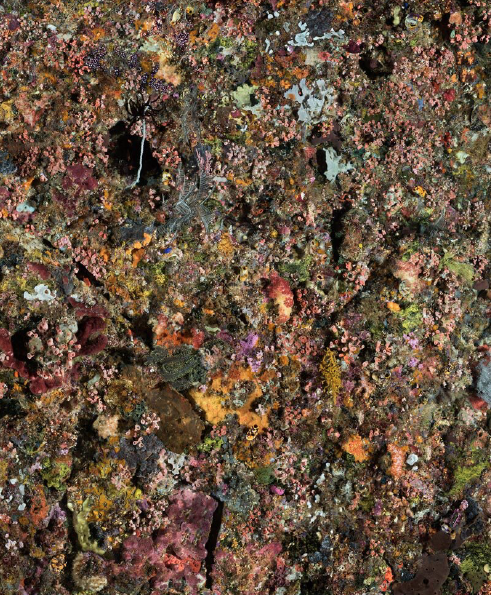
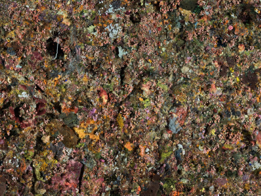
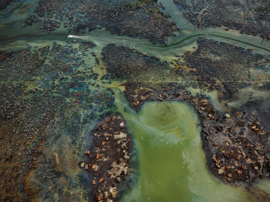
 Edward Burtynsky. Pengah Wall #1, Komodo National Park, Indonesia, 2017
Edward Burtynsky. Pengah Wall #1, Komodo National Park, Indonesia, 2017
This coral wall in Indonesia is a rare remnant of our globally diminishing coral reefs. In Komodo, unique local conditions allow reefs to flourish despite the corrosive forces of climate change. This ideal habitat is created through the convergence of strong daily tidal flows and nutrient-rich waters from the Indian Ocean. This pristine reef supports abundant life—fish, corals, crustaceans, cartilaginous aquatic creatures (mantas), marine reptiles (sea turtles), and mammals (dolphins). These dynamic forces made this environment a difficult one to photograph. Shot in multiple frames and stitched together later, the final result is a vibrant document of an increasingly rare ecosystem.
Indeed, coral bleaching may be more likely to occur here (as elsewhere) should sea water temperatures begin to rise. In 2016, the Great Barrier Reef in northeastern Australia, the world’s largest reef system, suffered a devastating mass bleaching event. In all, about 22 percent of the entire reef’s corals were lost. Further diminishing hope for recovery, a second wave of mass bleaching was recorded in 2017. Bleaching is not limited to Australia, and is seen on other coasts with increasing frequency as ocean temperatures rise and acidity increases. Australia is the world’s largest coal exporter, and many of the mines and ports are centred near Queensland, where reefs experienced the greatest damage. The tension here between conservation and industry has been lengthy and ongoing. While there is hope that the coral reefs will recover, the increased frequency of bleaching events will only put more stress on those that survive.
All works measure 148.6 x 198.1 cm
Pigment inkjet printing
Courtesy of the artist and Nicholas Metivier Gallery, Toronto
 Jennifer Baichwal - Nicholas de Pencier. Elephant Tusk Burn, Nairobi National Park, Kenya, 2018 Video, 7'58"
 Edward Burtynsky, Jennifer Baichwal y Nicholas de Pencier. AR #2, President Kenyattas Tusk Pile, April 28, Nairobi, Kenya, 2016
Jennifer Baichwal - Nicholas de Pencier. Elephant Tusk Burn, Nairobi National Park, Kenya, 2018. Video, 7'58"
In 2016, twelve stacks of ivory were set on fire and burnt in the Nairobi National Park. The authorities had amassed 105 tonnes of elephant tusks and a half tonne of rhinoceros horns. "Tomorrow, I'll set ablaze more than a hundred tonnes of ivory. It will be a pleasure to do my part to destroy any possibility that poachers and their accomplices might benefit from the slaughter of Kenya's elephants," President Uhuru Kenyatta wrote in the Kenyan newspaper "The Star." "If we don't take countermeasures, our children will be the first Africans in ten thousand years to grow up without these beautiful animals." It is estimated that every year in Africa, between 20,000 and 35,000 thousand elephants are slaughtered by unscrupulous hunters whose exclusive target is their precious tusks. For the most part, international trade in ivory has been prohibited since 1989. However, some African countries have succeeded in obtaining exemptions from the ban. The Kenyan government is currently putting pressure on the international community to sign a global ban on ivory trade.It is believed that, prior to European colonization, Africa may have been home to as many as 20 million elephants.1 Today, approximately 352,000 remain in the continent. In the lead-up to the historic tusk-burning event in 2016, Kenya Wildlife Service—in collaboration with a consortium of African and international anti-ivory groups, including Stop Ivory and the Tusk Trust—worked for over a year to organize and coordinate the burning of all of Kenya’s confiscated stores of ivory. The tusk piles were built over the course of one week, during which the city of Nairobi witnessed a massive downpour. In the days prior to the event, the pyres required twenty-four-hour monitoring to prevent theft. Despite the torrential rain, the pyramid- shaped piles caught fire once they were lit. In an interview during the week of the burn, Dr. Winnie Kiiru, regional technical advisor with Stop Ivory, the organization responsible (along with Kenya Wildlife Service) for recording every tusk before it was burned, said: I am pleased that even if I didn’t—or maybe many of us didn’t—do what we needed to do to keep these elephants alive, no one is ever going to benefit further from their death. So burn on. I want to see every piece turn into ashes. And I’m going to be here until that happens. And then I will issue a certificate to KWS that says “You did it. We destroyed 105 tons of tusks. We destroyed 1.35 tons of rhino horn.” May those animals rest. And no one is ever going to enjoy anything made from these tusks. These are ashes, and I’m happy.
Edward Burtynsky, Jennifer Baichwal y Nicholas de Pencier
AR #2, President Kenyatta’s Tusk Pile, April 28, Nairobi, Kenya, 2016
On April 30, 2016, the largest ivory burn in history took place in Nairobi National Park in Kenya. For decades, the Kenyan government had been stockpiling elephant tusks and rhino horn that had been confiscated from poachers. They decided that a dramatic public incineration of this cache would make a bold statement to the world that there is no market for ivory. The day before the conflagration, the artists documented the largest pyramid of tusks, the so-called “President’s Pile” that President Uhuru Kenyatta would set on fire the next day in a solemn ceremony in front of hundreds of dignitaries and press cameras. This photographic archive was achieved by taking more than 2,500 high-resolution stills of the three-metre-tall pile with a custom-built parallax DSLR rig from every angle possible. These images were then stitched together using specialized software into a highly detailed 3D mesh and texture map. The resulting virtual sculpture is a life-sized, photorealistic 3D model that can be explored using virtual or augmented reality platforms, and gives an exquisitely faithful representation of the complex monument of tusks that was burned to ash the next day. As a digital entity the sculpture is inherently ephemeral, and yet the striking verisimilitude of the virtual sculpture gives a visceral understanding of human-caused extinction.
Edward Burtynsky. Tetrapods #1, Dongying, China, 2016
These large tetrapods will be used to create seawalls and protect shorelines. Formed on-site from moulds like those at the bottom of the image, each one can weigh up to 80 tons. Tetrapods allow water to flow around them and prevent coastal erosion, a serious global threat. This form of seawall now covers approximately 60 percent (8,700 kilometres) of China’s coastline. Made of concrete, tetrapods are technofossils: human-produced objects that cannot naturally decompose, another geological marker of the Anthropocene.
Technofossils are human-generated objects that, if preserved in the strata, will serve as future geological markers through which the Anthropocene epoch can be considered. Cement is one of the most significant technofossils that humanity will leave behind. Invented by the Romans, concrete became a fundamental, global building material during the mid-twentieth century. Since that time, enough concrete has been poured to coat the earth in a two-millimetre-thick layer of the material. From 1995 to 2015, rapid urbanization and population growth saw the production of more than half of the planet’s total volume of concrete.1 In sum, as a human-made material, concrete is unparalleled in quantity. The tetrapods pictured here make use of concrete to mitigate another human-generated problem: climate change. When used for shoreline protection, tetrapod seawalls allow water to flow around them. This disperses the energy of breaking waves that would otherwise crash against a flat wall, eroding the shoreline. Along China’s coast, a region that comprises only 13 percent of China’s total land area, but contributes 60 percent of the country’s gross domestic product (GDP), continued erosion poses a serious threat. Technological advancements in machinery during the early twentieth century led to increased sediment displacement, mainly flux, in most large rivers around the world. By the 1950s, this sediment displacement began to reverse due to the rapid construction of dams, resulting in sediment load reduction below pristine conditions. This reduction of sediment downstream frequently results in riverbank erosion, as well as a decline in the nutrients deposited in floodplain areas, thereby undermining the chemical base of the ecosystem. Such sediment displacement is considered a global signal of the Anthropocene, as is delta subsidence, which began in the 1930s and is now a dominant warning signal for many coastal environments. Simultaneously, seawalls are built to reclaim wetlands for urban and industrial expansion, resulting in a stark decline in biodiversity. The need for more land to support the world’s most populous country, combined with environmental threats to existing settlement, has resulted in the construction of new seawalls covering over 60 percent of the total length of China’s coastline.
These large tetrapods will be used to create seawalls and protect shorelines. Formed on-site from moulds like those at the bottom of the image, each one can weigh up to 80 tons. Tetrapods allow water to flow around them and prevent coastal erosion, a serious global threat. This form of seawall now covers approximately 60 percent (8,700 kilometres) of China’s coastline. Made of concrete, tetrapods are technofossils – human-produced objects that cannot naturally decompose, another geological marker of the Anthropocene.
Edward Burtynsky. Eko Atlantic Development #1, Lagos, Nigeria, 2016
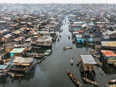
Over the past decade or two, Lagos has emerged as one of the economic capitals of Western Africa. As the city is composed of a series of islands and peninsulas on the Gulf of Guinea, natural processes of coastal erosion are exacerbated by climate change, putting much of Lagos at a high risk of flooding. With land at a premium, low-income residents and private developers have moved to create their own real estate. Since 1970, Lagos has grown at breakneck speed, from a city of around 1.4 million inhabitants to one of more than 20 million people in just two generations.1 The wealth disparity is stark, and a significant number of residents live in dense informal settlements.2 Makoko, and communities like it,
have no fortifications to protect inhabitants from climate change. Built on the water without infrastructure, the informal settlement boasts a population estimated to range from 40,000 to 300,000 people.3 Eko Atlantic, a nearby multi-billion- dollar artificial peninsula, has plans to house a quarter of a million people.
Over ten square kilometres of sand were dredged to create the peninsula that is attached to Victoria Island, Lagos’ financial centre.4 With the peninsula highly vulnerable to storm surges, the project includes the construction of a seawall known as the “Great Wall of Lagos.” Approximately 100,000 five-ton concrete blocks will be arranged to form the wall, which will extend over eight kilometres. However, what might protect the wealthy districts of Eko Atlantic and Victoria Island may end up directing damage from a storm to unprotected informal communities. Eko Atlantic, designed to employ 200,000 commuters largely in the financial and tech sectors, is meant to represent the new, wealthy Lagos. The real estate, including nearby Bar Beach, is so valuable that, in 2008, local police conducted violent economic evictions in the run-up to construction. Nigeria is the most populous country in Africa, with a rapidly growing population that by 2018 had expanded to more than 190 million people. In 2017, the United Nation’s World Population Prospects found that among the ten largest countries in the world, Nigeria’s population was growing the most rapidly.7 As such, the population of Nigeria is projected to surpass that of the United States shortly before 2050, at which point it would become the world’s third-largest country by population. Integral to the city’s fabric, the growing low-income communities of Lagos are nonetheless precarious in the face of climate change, politics, and capital.
-
All works measure 148.6 x 198.1 cm
Pigment inkjet printing
Courtesy of the artist and Nicholas Metivier Gallery, Toronto